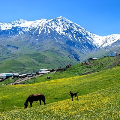
The Greater Caucasus Mountains stretch from north to south, spanning the territories of Azerbaijan, Georgia, Russia, and Armenia. These mountains are known for their rich flora and fauna, hosting rare and endemic plant and animal species. The Greater Caucasus is an ideal destination for both ecotourism and enthusiasts of mountaineering and trekking. Here, visitors can enjoy panoramic views, fresh mountain air, and an unforgettable nature experience.
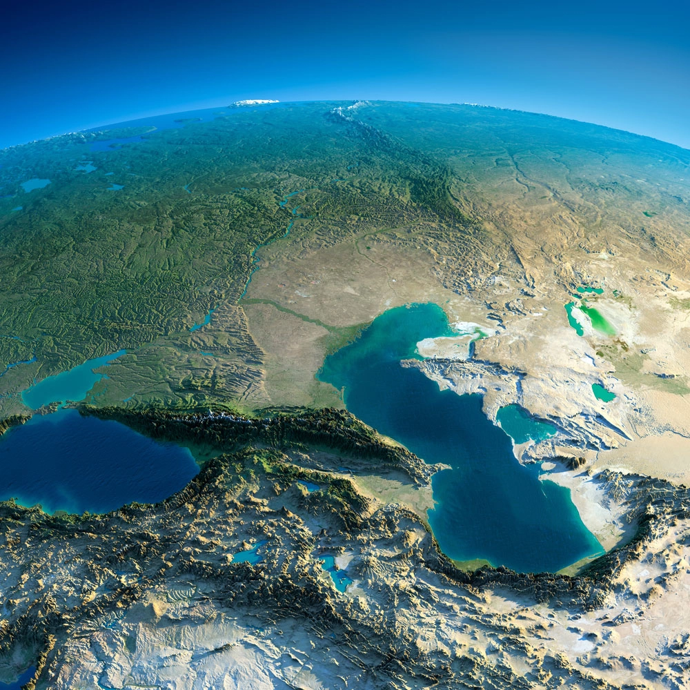
The Caucasus Mountains are an important mountain system located in the Eurasian continent, stretching approximately 1,100 kilometers from the Black Sea to the Caspian Sea. This mountain range serves as a natural boundary between Europe and Western Asia. The system includes the rugged Greater Caucasus in the north and the more fragmented Lesser Caucasus in the south. It is bounded by the Kuban and Terek rivers to the north and the Kura and Aras rivers to the south, creating diverse ecosystems ranging from alpine meadows to subtropical plains. Mount Elbrus, located in the Greater Caucasus, rises to 5,642 meters near the border with Georgia in southern Russia, and is considered the highest peak in Europe.
The Caucasus Mountains span Russia, Georgia, Armenia, Azerbaijan, Turkey, and Iran, and throughout history have formed a complex geopolitical region serving as an important corridor for migration, trade, and conflicts. Geologically, this mountain system was formed by the collision of the Arabian and Eurasian tectonic plates. As a result, a dramatic landscape has emerged, featuring active fault lines, extinct stratovolcanoes like Elbrus, ongoing seismic activity, deep gorges, glaciers, and high plateaus. The Greater Caucasus stretches approximately 1,200 kilometers from the Taman Peninsula to the Absheron Peninsula; its northern slopes are steep, while the southern slopes are more gradual. The Lesser Caucasus extends from the Anatolian plateau to the northern mountainous regions of Iran, with peaks such as Ararat (Aragats) in Armenia reaching 4,090 meters.
The region is known for its exceptional biodiversity and, due to its isolation by mountains and diverse climatic conditions, is one of the world's most important biodiversity hotspots. Over 6,500 plant species are found here, about 25% of which are endemic. The Caucasus is also home to various wild animals, including the Caucasian ibex, leopard, and brown bear. Economically, the mountains influence surrounding areas—particularly the Caspian lowlands—with oil and gas resources, forest wealth, and hydropower potential. However, issues such as soil erosion and climate change threaten these resources.
Culturally, the Caucasus is a mosaic region inhabited by over 50 ethnic groups speaking languages from the Indo-European, Turkic, and Caucasian language families. Historically, the mountains have served both as a barrier and a corridor for human movement.
Geography
Location and Extent
The Caucasus Mountains are a significant mountain system connecting Europe and Asia, located approximately between 41°–44° north latitude and 40°–50° east longitude. The range extends about 1,100 km from northwest to southeast, stretching from the western shores of the Black Sea to the Caspian Sea in the east. The system includes the Greater Caucasus in the north and the Lesser Caucasus in the south, covering a total area of approximately 440,000 km². Elevations rise from coastal plains to high peaks exceeding 5,000 meters.
Geopolitically, the Caucasus Mountains act as a natural boundary between the North Caucasus in the Russian Federation and the South Caucasus, which includes Georgia, Azerbaijan, and Armenia. The mountain range also partially extends into northeastern Turkey and northwestern Iran, influencing regional borders and cultural interactions. Traditionally, the boundary between Europe and Asia is defined by the Kuma-Manych Depression in the north, highlighting the Caucasus as an intercontinental transition zone.
The Caucasus Mountains are bounded in the west by the Pontic Mountains along the Black Sea coast, in the east by the Kopet Dag range in the southeast of the Caspian region, and in the north by the southern Russian plains. These areas create a transition to the lower Kuban and Terek river basins. The surrounding geographical features emphasize the Caucasus as a high mountain barrier isolated from wide plains and coastal areas.
Main Ranges
Structurally, the Caucasus Mountains are divided into several major ranges, the most significant being the Greater Caucasus in the north. This range extends approximately 1,200 km from the Taman Peninsula on the Black Sea coast to the Absheron Peninsula on the Caspian Sea, with an average width of 100–150 km. Its highest peaks rise above 5,000 meters; for example, Mount Elbrus reaches 5,642 meters.
The Greater Caucasus is divided into three main sections:
-
Western Greater Caucasus (from the Black Sea to Mount Elbrus)
-
Central Greater Caucasus (the section containing the highest peaks)
-
Eastern Greater Caucasus (descending towards the Caspian)
These divisions correspond to differences in rock composition and tectonic activity. The central part is distinguished by the strongest tectonic uplift.
Parallel to the south of the Greater Caucasus lies the Lesser Caucasus, approximately 600–800 km long. This range extends from northeastern Turkey through Georgia, Armenia, and Azerbaijan, merging into the Armenian plateau. Elevations generally range between 2,000–3,300 meters, with the highest peak being Mount Aragats at 4,090 meters. The Lesser Caucasus is characterized by folded structures and volcanic relief, gradually transitioning into the expansive Armenian plateau. This range is considered a natural continuation of the Anatolian plateau and influences regional river networks and biodiversity corridors.
Between these two main ranges lies the Transcaucasian Lowland. This broad plain covers much of Georgia, Armenia, and Azerbaijan. To the west is the Colchis Plain, while to the east lies the Kura-Aras Plain. The Colchis Plain has a humid climate, whereas the Kura-Aras Plain is drier, stretching toward the Caspian along the valleys of the Kura and Aras rivers. This lowland reaches up to 200 km in width in some areas and is covered with thick alluvial deposits. Major river systems have formed here, and the region serves as an important geographical line separating the northern and southern mountain ranges, as well as enabling intensive agriculture due to its fertile soils.
Continuation of the Caucasus System
The Caucasus orogen system connects to neighboring mountain systems through several additional subranges. The Pontic Mountains in northern Turkey are considered the western continuation of the Greater Caucasus, stretching approximately 1,000 km along the Black Sea coast. The highest peak here is Mount Kaçkar, which rises to 3,937 meters.
In southwestern Georgia, the Adjara–Imereti range branches off from the Lesser Caucasus and extends southward. This range reaches elevations over 2,800 meters and connects the Colchis Plain to the Trialeti range.
Further southeast, the Talysh Mountains, located in Azerbaijan and Iran, are considered the continuation of the Lesser Caucasus along the Caspian coast. The maximum elevation here is 2,477 meters. The Talysh Mountains are distinguished by their folded relief and subtropical foothills and provide a transition to the Alborz Mountains.
These subranges enhance the overall connectivity of the Caucasus mountain system and strengthen its role as a natural barrier between Europe and Asia. Of course! I have corrected the grammar in your long text on geology, relief, and hydrology, and rewritten the sentences in a neat and fluent manner. Below is the fully edited version:
Geology
Formation and Tectonics
The formation of the Caucasus Mountains is mainly associated with the Alpine orogeny. This large-scale mountain-building phase resulted from collisions between the Arabian and Eurasian plates. The process began approximately 25 million years ago, during the late Oligocene, as the northward-moving Arabian plate advanced toward the southern edge of Eurasia. The convergence rate of the plates is about 1.8–2.2 cm per year, generating significant tectonic deformation in the region.
This interaction gradually closed remnants of the ancient Tethys Ocean, resulting in the uplift and structural development of the Greater and Lesser Caucasus as part of the Alp–Himalayan orogenic belt. The northward movement of the Arabian plate intensified crustal compression, thrust faults, and folding processes across the Caucasus region.
One of the main structural features is the Main Caucasus Thrust. This major fault defines the boundary between the Greater Caucasus and the northern foreland lowlands, concentrating north-south compression. As a result, thrust sheets and folded-thrust belts have formed, particularly on the southern slopes of the Greater Caucasus. Ongoing deformations continue to shape the region's relief today.
The evolutionary stages of the Caucasus orogen are characterized by successive tectonic events. During the Miocene, uplift of the Greater Caucasus intensified, associated with the inversion of older Mesozoic rift basins and the activation of major faults such as the Main Caucasus Thrust. In the Lesser Caucasus, volcanism, subplate processes, and lithospheric stretching from the Pliocene to the Quaternary produced extensive basalt and andesite fields.
Related tectonic features include ophiolite outcrops. These are remnants of oceanic crust from the closing Tethys Ocean thrust onto the continental surface, mainly associated with subduction and obduction processes during the Late Cretaceous–Eocene. Metamorphic core complexes in the Greater Caucasus reveal exposures of mid-crustal rocks, which emerged during Miocene extension and erosion, illustrating the parallel occurrence of compression and local stretching during orogen development.
Composition and Resources
The Caucasus Mountains are distinguished by diverse geological composition, with widespread sedimentary, magmatic, and metamorphic rocks.
-
Sedimentary rocks — mainly limestones, sandstones, and shales from the Jurassic and Cretaceous periods — form the primary folded structure of the Greater Caucasus.
-
Magmatic rocks — widespread in the Lesser Caucasus due to volcanism during the Pliocene–Quaternary — include intrusive and extrusive rock complexes such as granite and basalt.
-
Metamorphic rocks — gneisses and schists — belong to the Paleozoic basement of the Greater Caucasus and are exposed in massifs like Dzirula.
Soil cover varies according to elevation and underlying rock type. In the foothill zones, fertile black soils (chernozems) rich in organic matter and with neutral pH develop. Above 1,800 meters, particularly on crystalline magmatic and metamorphic rocks, podzolic soils with strong leaching form in forest zones. In the alpine zone, thin humus-rich mountain-meadow soils develop, helping to retain water in subalpine and alpine regions.
The region is rich in mineral resources:
-
Oil and natural gas are concentrated along the Caspian Sea coastal areas.
-
Manganese deposits in Chiatura, Georgia, and copper and polymetallic ores in Kajaran and Kapan, Armenia, are notable.
-
Coal layers extend from the Donetsk basin to the outskirts of the North Caucasus.
Geothermal activity manifests along tectonic faults as hot springs. In Armenia and Georgia, these waters reach temperatures up to 64°C, making them promising for future renewable energy potential.
Relief
Famous Peaks
In the Greater Caucasus range, elevations exceed 5,000 meters. The highest peak, Mount Elbrus (5,642 m), is considered the tallest mountain in Europe. Dykhtau (5,205 m) is the second highest, and Shkhara (5,193 m) ranks third. Mount Kazbek (5,054 m) is famous for its pyramid-shaped silhouette.
The highest point in Azerbaijan is Mount Bazardüzü (4,466 m), while in Armenia, Mount Aragats (4,090 m), an extinct volcano, stands out. Dombay-Ulgen (approximately 4,046 m) and other peaks showcase the diversity of high-mountain landscapes in the Caucasus.
The history of mountaineering in the region began in the 19th century, with the first ascents of Elbrus and Shkhara forming the foundation for modern climbing routes.
There are more than 10 extinct or dormant volcanoes in the Caucasus. Elbrus and Kazbek are dormant stratovolcanoes, while Aragats and other volcanic peaks are inactive.
Hydrology and Glaciers
The hydrology of the Caucasus Mountains is characterized by a dense river network formed from precipitation in high-altitude areas and glacier melt.
-
Rivers flowing north: Kuban River (870 km, basin 61,000 km²), Terek River (600 km, basin 43,700 km²).
-
Rivers flowing south: Kura–Araz system (total length 1,515 km, basin 198,000 km²), Aras River (1,072 km), Rioni River (327 km, basin 13,400 km²).
Together, these rivers and their tributaries drain an area of over 500,000 km², supporting ecosystem sustainability in the region.
Glaciers
Glaciers are mainly concentrated in the Greater Caucasus. There are approximately 2,000 glaciers covering around 1,400 km², accounting for over 70% of all glaciers in the Caucasus. The Bezengi Wall in the central Greater Caucasus is famous for its extensive ice fields, with glacier areas exceeding 20 km². The largest glacier is the Bezengi Glacier, covering 39 km².
In recent decades, rising temperatures have caused rapid glacier retreat. Between 2000 and 2020, glacier area decreased by an average of 23%. Since the late 20th century, the annual retreat rate of glacier termini has averaged 8 meters. Climate change has further intensified seasonal melting processes.
Mountain Lakes and Karst Waters
High-altitude areas feature numerous mountain lakes (tarns). For example, the Abudelavri Lakes in the Kazbek region are situated above 2,800 meters and were formed by glacial erosion.
The Colchis Lowland (along the Black Sea coast) is rich in marshes and coastal lagoons and has unique biodiversity.
In areas with extensive limestone rocks, karst landscapes have formed. Especially in the Racha Massif, karst aquifers create abundant springs. These springs feed rivers with clear, mineral-rich waters.
Hydropower Potential
The upper reaches of Caucasus rivers have steep gradients, with some sections dropping more than 10 meters per kilometer. This creates significant hydropower potential.
For example, the Enguri Hydroelectric Station is located on a tributary of the Rioni River. The dam height is 271 meters, and its annual production capacity exceeds 1,300 MW. It is the largest hydropower facility in the South Caucasus.
Climate
Variation by Zones
In the Caucasus Mountains, the climate exhibits clear vertical zonation depending on altitude:
-
Subtropical lower mountain zones (below 800 m, especially along the Black Sea coast) — winters are mild, summers are warm and humid; the average temperature rarely drops below 0°C.
-
Middle slopes (800–2,500 m) — annual average temperature 10–20°C; sufficient rainfall and mixed forests make these areas suitable for vegetation.
-
High alpine zone (above 2,500 m) — average temperature below 0°C; from 2,800–3,000 m permanent frost (permafrost) occurs.
There are also significant climate differences from west to east:
-
Western Caucasus — humid under the influence of the Black Sea; annual precipitation exceeds 2,000 mm; subtropical conditions prevail.
-
Cfa climate zone — humid subtropical.
-
Eastern slopes — in the rain shadow of the Caspian Sea; arid to semi-arid climate; annual precipitation 300–500 mm; Köppen Dsa and BSk classification.
-
Alpine tundra (ET) — cold, dry conditions typical of high-altitude zones.
Orographic effects increase precipitation and create rain shadows on leeward slopes. In the north, steppe conditions prevail, while semi-desert conditions form in the south and east. Föhn winds cause rapid temperature changes.
Seasonal Patterns
The Caucasus exhibits distinct seasonal variations:
-
Winters — cold and snow-covered. In high-mountain areas above 2,500 m, snow depth can exceed 3 m. Temperatures range from -20°C to -30°C; in lower zones, -5°C to 0°C.
-
Summers — in lower zones 20–30°C, in some valleys exceeding 35°C; mountain peaks 5–15°C, with thunderstorms and heavy rain.
Precipitation follows a bimodal pattern: more in autumn and spring due to Black Sea humidity, less in summer. Annual precipitation: 100–200 mm in the arid eastern zones, 1,000–4,000 mm on western slopes.
Natural Events and Climate Change
Heavy rains can trigger landslides and floods. For example:
-
Floods in Tbilisi in 2002
-
Flood events in northern Armenia in May 2024
Long-term trends indicate that since the early 20th century, temperatures in the Caucasus have risen by 1–2°C; since the 1970s, the warming rate accelerated to 0.4°C per decade. As a result, snow lines have risen by 100 m, glaciers have retreated, and river flow patterns have changed. Since 2000, glacier area has decreased by over 23%, with an average retreat of 600 m by 2024.
Ecology
Flora and Vegetation Cover
The flora of the Caucasus Mountains is characterized by diverse altitudinal zones resulting from the region’s steep relief and climatic variations. In the lower mountain areas and western slopes up to approximately 1,000 meters, the Colchis broadleaf forests dominate. Here, thermophilic species such as oaks (Quercus spp.), chestnuts (Castanea sativa), and hornbeams (Carpinus spp.) thrive under the humid subtropical conditions influenced by the Black Sea.
Between 1,000 and 2,000 meters, beech-fir zones prevail. Eastern beech (Fagus orientalis) and Nordmann fir (Abies nordmanniana) form dense mixed forests. At higher northern slopes, oriental spruce (Picea orientalis) can also be found.
Above 2,000 meters, subalpine meadows begin. Here, grasses and shrubs, such as the Caucasian rhododendron (Rhododendron caucasicum), dominate up to 3,000 meters, providing habitat for various pollinators.
On the highest peaks above 3,500 meters, nival deserts form. Cold-tolerant lichens and mosses make up the sparse vegetation; permanent snow and ice prevent the spread of vascular plants.
The Caucasus is one of the richest regions in the world in terms of plant endemism. About 25% of the approximately 6,300 vascular plant species are endemic. Many species are Tertiary relics that survived from a warmer period. For example, the Caucasian wingnut (Pterocarya fraxinifolia) grows in riverine forests in eastern Greater Caucasus and Transcaucasia and plays an ecological role in stabilizing riverbanks. Other relic species, such as yew (Taxus baccata) and boxwood (Buxus colchica), are preserved in protected mountainous areas, representing ancient Tertiary flora. In the Caucasus Reserve, vascular plant endemism reaches 26.2%, highlighting the region as a “hotspot” of temperate climatic biodiversity.
Forests cover approximately 40% of Georgia, 11.8% of Azerbaijan, and 11.5% of Armenia. These areas include broadleaf, coniferous, and mixed forests extending from the coasts to mountain zones up to 2,700 meters. Ancient yew forests and dense boxwood in the Colchis sector demonstrate the continuity of old forest ecosystems and provide habitat corridors for endemic understory plants.
Human activity has significantly impacted Caucasus vegetation. In the late 20th century, post-Soviet economic changes, logging for fuel, and illegal deforestation resulted in annual deforestation of 1–2%, leading to the loss of up to 55% of potential forest cover in the South Caucasus.
Invasive species such as Himalayan balsam (Impatiens glandulifera) have spread in disturbed riparian zones, outcompeting native flora and reducing biodiversity in lower mountain forests. These effects have fragmented subalpine meadows and accelerated erosion on deforested slopes. However, in some areas, forests have begun to regenerate since the early 2000s following the abandonment of agricultural land.
Fauna and Biodiversity
The Caucasus Mountains are home to approximately 6,400 vascular plant species and a variety of animal groups. There are over 130 mammal species and more than 400 bird species, with plant endemism exceeding 25% and about 20% for mammals. This diversity is mainly divided into three ecological zones: lower elevations feature Caucasian mixed forests (broadleaf and coniferous), mid-elevations have mountain meadows and shrubs, and above the tree line, alpine tundra allows specialized species to survive in harsh conditions.
These ecosystems provide habitat for over 130 mammals, more than 400 birds, and numerous reptiles and amphibians.
Caucasian mammals are well-adapted to the mountainous terrain. Key species include:
-
West Caucasian tur (Capra caucasica) – a goat-antelope species native to the western slopes, agile on rocky terrain.
-
Caucasian chamois (Rupicapra rupicapra caucasica) – a subspecies limited to the Greater and Lesser Caucasus, playing a key role in the alpine food chain for predators.
-
Brown bear (Ursus arctos) – widespread in forests and subalpine zones, feeding on berries, roots, and small animals; occasionally attacks livestock.
-
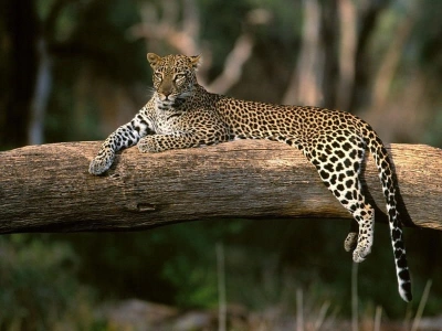
Persian leopard (Panthera pardus tulliana) – a critically endangered subspecies, with only 10–20 individuals in the South Caucasus, primarily inhabiting remote forests and rocky areas. It preys on ibex and other mammals but is severely isolated. Historically, endemic subspecies such as the Turan (Caspian) tiger (Panthera tigris virgata) existed but disappeared after the 1970s.
Bird species are also very rich; more than 400 species use the Caucasus as a Black Sea–Caspian migration corridor, ensuring seasonal movements between Europe and Asia. The Caucasian snowcock (Tetraogallus caucasicus) inhabits high rocky areas and alpine meadows, preserving its camouflaging fur colors.
Reptiles, such as Vipera dinniki and Vipera kaznakovi, are adapted to live at various elevations from lower forests to subalpine zones. Their venom allows them to hunt small rodents and birds. Amphibians, such as the Caucasian salamander (Mertensiella caucasica), are protected relic endemics, restricted to streams in western Caucasus and abundant in moist forest understories.
Biodiversity in the Caucasus faces various threats:
-
Hunting – for trophies and skins of large mammals.
-
Habitat fragmentation – populations are isolated due to infrastructure development and overgrazing, reducing genetic diversity.
According to 2024 data, glacier retreat reduces drinking water supplies, and protected areas are insufficient to conserve alpine and mountain species. For example, the West Caucasian tur population has declined by over 50% since the 1990s; the main causes are poaching and competition with livestock in pastures. These pressures increase the vulnerability of endemic species and highlight the need for targeted conservation measures to maintain ecological balance.
History
Ancient and Medieval Periods
The Caucasus region presents some of the earliest evidence of human habitation. The Dmanisi archaeological site in southern Georgia has uncovered Homo erectus skeletons dating approximately 1.85–1.78 million years ago. These remains, including skulls, jaws, and postcranial bones, represent the oldest reliable evidence of humans outside Africa and suggest possible subsistence behaviors using primitive tools.
The Bronze Age (c. 3000–1000 BCE) in the South Caucasus saw the development of pastoral nomadic life, metalworking, and monumental burial practices. Kurgans (large earthen mounds) extended from north to south, serving as elite tombs with weapons, pottery, and horse remains. In western Georgia, the Colchian culture developed during the Bronze and Early Iron Ages (c. 1500–600 BCE) and was known for bronze casting and gold extraction technologies. The legend of the Golden Fleece likely originated from the tradition of panning alluvial gold from sheep wool in the Rioni River.
In antiquity, strong kingdoms existed in the region. The Urartu kingdom was located in the Armenian Highlands around Lake Van (9th–6th centuries BCE), constructing fortified cities (e.g., Erebuni) and extensive irrigation systems, developing agriculture in mountainous areas. Greek colonization began in the 6th century BCE along the Black Sea coast, with colonies in Colchis (modern western Georgia) and Iberia (eastern Georgia), where merchants traded wine, metals, and slaves.
From the 2nd to the 7th century, Roman and later Byzantine influence expanded through military campaigns and alliances; Iberia and Colchis (Lazica) became client states, Roman legions protected passes, and Christianity was promoted. Consequently, Iberia adopted Christianity in 337 CE.
During the Middle Ages, the Caucasus faced various invasions. The 7th century saw Arab conquests, and the 13th century witnessed Mongol invasions, which transformed the region. Between the 11th and 13th centuries, the Kingdom of Georgia reached its peak under David IV (1089–1125) and Tamar (1184–1213). Fortresses (Ananuri, Narikala) were built against Seljuk Turks and Mongols, and architecture, literature, and Orthodox Christianity flourished.
The Caucasus was also a trade crossroads. Silk Road branches passed through the Darial Gorge, connecting the Caspian plains to the Black Sea, facilitating the exchange of silk, spices, and ideas with Iran, Byzantium, and Central Asia from the 1st millennium BCE onward.
Modern Developments
In the 19th century, the Russian Empire intensified its efforts to control the Caucasus. This period was marked by the Caucasian War (1817–1864). During the war, Russian forces subdued local resistance in the North Caucasus, including the Islamic insurgents led by Imam Shamil, thereby bringing the region under imperial control. The occupation involved harsh military tactics and mass relocations, resulting in the Caucasus becoming part of the empire under Russian administrative authority.
Simultaneously, the late 19th century saw the Baku oil boom. Starting from small-scale production in the 1870s, by the early 20th century, Baku supplied more than half of the world’s oil production. Foreign investments, including factories and pipelines by the Nobel family, transformed Baku into a global energy hub.
From 1920 to 1991, under Soviet rule, the Caucasus underwent rapid industrialization. The USSR’s five-year plans prioritized heavy industry, oil extraction, and infrastructure development. Oil fields in Baku were expanded as national assets to support the socialist economy. This period was also marked by repressive policies; for example, during the 1944 “Operation Lentil,” approximately 400,000–500,000 Chechens and Ingush were deported from the North Caucasus to Central Asia, with one-third dying due to hunger, disease, and harsh weather.
Environmental projects include the Mingachevir reservoir. Completed in the 1950s on the Kura River, it provided irrigation and hydroelectric power for agriculture, boosting regional productivity but altering local ecosystems.
Following the collapse of the USSR in 1991, several armed conflicts erupted in the South Caucasus:
-
Nagorno-Karabakh Wars (1988–1994) – between Armenian separatists and Azerbaijani forces, resulting in approximately 30,000 deaths and hundreds of thousands of displaced persons. In 2020, Azerbaijan regained significant territories.
-
Separatist movements in Georgia – wars in Abkhazia and South Ossetia, 1992–1993, displaced over 200,000 Georgians; in 2008, the Russia-Georgia war resulted in these regions gaining de facto independence.
-
North Caucasus – First Chechen War (1994–1996) and Second Chechen War (1999–2009), restoring federal control by Russian forces, causing widespread destruction and human rights violations.
The 2020 Nagorno-Karabakh ceasefire was signed on November 9 under Russian mediation, ending the 44-day war. Russian peacekeepers were deployed, and Armenians withdrew from occupied territories. In September 2023, Azerbaijan regained full control over Nagorno-Karabakh through military operations; the remaining Armenian population left, and the self-proclaimed Nagorno-Karabakh Republic was dissolved on January 1, 2024. Russian peacekeepers left the region in June 2024. In August 2025, an Armenian-Azerbaijani peace agreement mediated by the US established a permanent ceasefire, full diplomatic relations, territorial integrity respect, and a 43 km transit corridor, with implementation continuing until November 2025.
Climate change, rising temperatures, drought, and glacier melt have added migration pressures. Resource shortages and ecological disruption in mountainous regions have increased, with vulnerable communities in countries like Georgia relocated through eco-migration programs. Overall, since 1988, over one million people in the South Caucasus have been displaced, deepening environmental problems.
Human Geography
Political Regions
The North Caucasus encompasses the northern slopes of the Greater Caucasus and surrounding areas and is entirely within the Russian Federation. It is governed as part of the North Caucasus Federal District and consists of seven republics: Adygea, Dagestan, Ingushetia, Kabardino-Balkaria, Karachay-Cherkessia, North Ossetia–Alania, and Chechnya. The total area is approximately 170,000 km² under federal control centered in Moscow. These entities have semi-autonomous status within the Russian federal structure, with administrative centers in Grozny (Chechnya) and Makhachkala (Dagestan).
The South Caucasus lies south of the Greater Caucasus and is divided among three independent states: Georgia, Azerbaijan, and Armenia, covering approximately 186,000 km². Georgia controls the central and western parts of the Greater Caucasus and much of the Lesser Caucasus, including major mountain passes and the highlands of Svaneti. Azerbaijan covers the eastern slopes of the Greater Caucasus and the Talish Mountains in the southeast, while Armenia governs most of the Lesser Caucasus, including the Armenian Highlands and Mount Ararat. These borders reflect post-Soviet arrangements from the early 1990s, with mountains acting as natural boundaries.
Several disputed territories exist in the Caucasus. In the northwest of the Western Greater Caucasus, Abkhazia and South Ossetia are claimed by Georgia but function as de facto independent entities supported by Russia; recognition remained limited until 2025 (by Venezuela, Nicaragua, Nauru, and Syria). In the southeast, Nagorno-Karabakh – historically contested between Azerbaijan and Armenia in the Lesser Caucasus – came fully under Azerbaijani control after the 2023 operation; most Armenians left. Until 2025, Azerbaijan initiated legal actions against former Armenian officials, while Armenian-Azerbaijani peace talks continued. In August 2025, Armenia and Azerbaijan signed a preliminary framework peace agreement to normalize relations and end hostilities, with final ratification expected by November 2025.
Internationally, the Caucasus plays a role in regional geopolitics through programs like the EU’s Eastern Partnership. Since 2009, Armenia, Azerbaijan, and Georgia have been supported in strengthening political and economic ties, with assistance for reforms and coordination projects. The mountains also define borders with Turkey and Iran: Turkey shares mountainous borders with Georgia and Armenia along the Lesser Caucasus, while Iran borders Azerbaijan and Armenia in the southern Talish and Zangezur regions, influencing strategic transit routes despite the absence of enclaves.
Ethnic and Cultural Diversity
The Caucasus region is home to a rich mosaic of over 50 ethnic groups. In the North Caucasus, the main groups are Circassians (Northwest Caucasian languages), Chechens and Ingush (Northeast Caucasian languages), and Avars (Dagestani, Northeast Caucasian languages). In the South, Georgians (Kartvelian languages), Armenians (Indo-Iranian languages), and Azerbaijanis (Turkic languages) reside. This diversity results from the mountains’ role as natural passes and borders, as well as isolated communities and cultural exchanges.
Approximately 50 languages are spoken in the Caucasus, mainly belonging to three native language families – Kartvelian, Northeast Caucasian, and Northwest Caucasian – with influences from Indo-European and Turkic languages. A famous example is the Ubykh language, a Northwest Caucasian language; the last speaker, Tevfik Esenç, died in 1992, making it extinct. Writing systems vary: Georgian and Armenian use ancient alphabets, North Caucasian languages often use Cyrillic, and Azerbaijani adopted the Latin script in the 20th century.
Culture in mountain communities revolves around hospitality and craftsmanship. For example, Georgia’s supra – a ritualized feast – is led by a tamada, enriched with poetry, social interactions, and shared meals. Georgian polyphonic songs, with complex harmonies of three or more independent vocal lines, are tied to daily life and rituals; in 2001, they were inscribed on UNESCO’s Intangible Cultural Heritage list.
Traditional arts continue to thrive, for instance, Kubachi village in Dagestan is renowned for silver jewelry craftsmanship; bracelets, daggers, and other ornaments are made using techniques passed down through generations.
In terms of religion, the Caucasus reflects a mix of major faiths and ancient pre-Christian elements: Orthodox Christianity has been present in Georgia and Armenia since the 4th century; Sunni Islam in the North Caucasus, and Shia Islam in Azerbaijan, spread from the 7th century onward. Ancient pagan traditions persist in folklore, animal sacrifices among the Ossetians, and syncretic rituals.