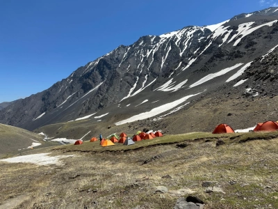
A successful and safe expedition to Mount Bazarduzu, the highest point in Azerbaijan, depends on professional equipment and a well-planned nutrition strategy. This guide provides a detailed overview of the three-layer clothing system suitable for steep moraine slopes and changing alpine weather conditions, technical climbing equipment, and a high-calorie food plan. From the official permits required for Shahdag National Park and the border zone to camping equipment, you can easily plan every detail using our checklist. Explore our comprehensive checklist to ensure you are fully prepared for the summit push to 4,466 metres and to minimise risks in the mountains.
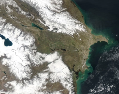
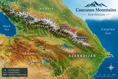
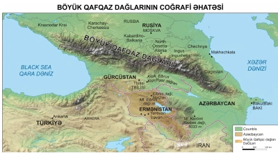
Mount Bazarduzu (4,466 m), rising along the Main Caucasus Range on the border between Azerbaijan and Dagestan (Russian Federation), is the highest geographical point in Azerbaijan. Resembling a natural border wall, this imposing massif is one of the region’s most significant mountaineering destinations, featuring physically demanding high-altitude terrain, moraine fields, and glacial valleys.
This guide provides a detailed analysis of the Mount Bazarduzu expedition, including route details, acclimatization principles, required official permits, and essential technical equipment.
Geographical and Technical Profile of the Summit
Geologically, the Bazarduzu massif consists of clay shales and sandstones dating from the Lower and Middle Jurassic periods. Weathering has resulted in extensive deposits of loose rocks, including moraines and scree slopes.
|
Parameter |
Details |
|
Elevation |
4,466 metres |
|
Mountain Range |
Main Caucasus Range (watershed ridge) |
|
Location |
Gusar District (Shahdag National Park area) |
|
Classic Climbing Grade |
1B–2A (normal route under the Russian mountaineering classification) |
|
Base Camp Elevation |
Approximately 2,850–3,250 m (Yatukh Valley / river confluence) |
|
Elevation Gain and Loss (Summit Day) |
+1,500 m / -1,500 m |
|
Summit Day Distance |
Approximately 14–16 km (round trip) |
Permits and Documentation Requirements
Since Mount Bazarduzu lies within the state border zone and a specially protected natural area, obtaining official permits before starting the expedition is a legal requirement.
State Border Service (SBS) Permit: Permission to enter the border zone must be obtained by submitting copies of the expedition participants’ identification documents and a detailed route plan. For foreign nationals, the process should be initiated well in advance, at least 15–20 working days before the expedition.
Shahdag National Park Entry Permit: Entry permits can be obtained through the relevant portal of the Ministry of Ecology and Natural Resources or local forestry offices, subject to the applicable fees based on the number of participants and tents.
Recommendation: The group leader should carry both printed and digital copies of all permits. Document checks at the border outpost in Gusar District are mandatory.
Best Season and Weather Conditions
The interaction between humid air masses from the Caspian Sea and the mountainous terrain creates rapidly changing and unpredictable weather conditions on Mount Bazarduzu.
Best Climbing Window (July–August): This is the classic climbing season, when snow cover along the ridges is generally at its lowest and crevasses and trails are more clearly visible. Night-time temperatures typically range from -2°C to +4°C, while daytime temperatures range from +8°C to +15°C, depending on wind conditions.
Early Season (June): Firm snow and névé often remain on the slopes. Crampons and an ice axe are essential during this period.
Late Season (September): Although conditions may be relatively dry and clear, sudden severe frosts and the first snowstorms of the season can occur above 3,500 metres.
Standard Expedition Itinerary (3-Day Route)
To reduce the risk of altitude sickness and allow the body to adapt to elevations above 4,000 metres, the itinerary should span at least three days.
Day 1: Baku – Guba/Gusar – Near Khinalig/Laza – Base Camp (2,800 m)
Logistics: Travel from Baku towards Gusar or Guba, followed by a transfer in 4x4 off-road vehicles (UAZ, Niva, or specialised mountain transport) along the river valley to the base camp area.
Activities: Set up tents, explore the surrounding area, and identify a water source. In the evening, take a short acclimatization hike to approximately 3,100 metres, followed by an early rest.
Day 2: Summit Attempt – 4,466 m – Return to Base Camp
Early Morning Departure (03:00–04:00): The ascent begins before dawn using headlamps. An early start helps avoid the deterioration in weather that often occurs around midday or after 13:00, reducing exposure to fog and thunderstorms.
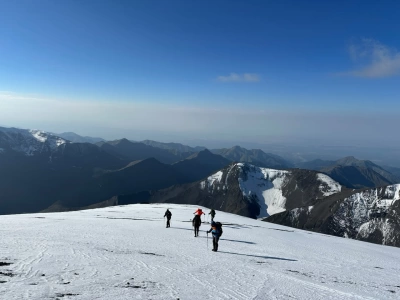
Moraine Slopes and Ridge Access: Ascend steep, scree-covered slopes to reach the southwestern ridge.
Summit Ridge and Plateau: Above approximately 4,200 metres, the terrain becomes more open, eventually leading to the summit marker of Mount Bazarduzu, consisting of a metal structure and triangulation marker.
Descent: After a short break at the summit, begin the descent at around 11:00–12:00. Return to base camp is expected between approximately 15:00 and 17:00.
Day 3: Packing Up Camp and Returning to Baku
-
Clean the campsite and follow the Leave No Trace principles.
-
Transfer by off-road vehicle to the main road and return to the capital.
Equipment and Safety System
Mount Bazarduzu is less about highly technical climbing and more about physical endurance, appropriate layering, and being properly equipped for high-altitude conditions.
Clothing System (The Three-Layer Principle)
Base Layer: Thermal underwear made of synthetic fabric or merino wool to wick moisture away from the body.
Insulation Layer: A fleece jacket and a lightweight down jacket.
Outer Shell: A waterproof and windproof membrane jacket, such as Gore-Tex, to protect against wind, heavy rain, and snow.
Footwear: Stiff-soled B2 mountaineering boots or sturdy trekking boots that provide good ankle support. Soft sports shoes increase the risk of injury on moraine terrain.
Trekking Poles: Essential for maintaining balance and reducing strain on the knees when crossing loose, rocky slopes.
Navigation and Communication: Offline topographic GPS tracks and satellite communication devices, such as Garmin inReach, help prevent disorientation when fog reduces visibility.
Tent and Sleeping System: A wind-resistant four-season tent and a sleeping bag with a comfort rating of at least -5°C.